i75/85 Atlanta Traffic Maps by Cross Streets


Interstate 75 and 85 Atlanta Traffic Maps and Road Conditions
Google


i-75 / i-85 Atlanta Traffic ...


On page load traffic map is centered on i75/i85 at North Ave ...
use elevation controls to zoom map
.


Zoom Traffic to:


> i-75/85 at Arthur Langford
> i-75/85 at Decatur St
> i-75/85 at Edgewood Ave
> i-75/85 at Ellis St
> i-75/85 at Freedom Parkway
> i-75/85 at Georgia Ave
> i-75/85 at Linden Ave
> i-75/85 at MLK Jr Dr
> i-75/85 at North Ave
> i-75/85 at Ormand St
> i-75/85 at Peachtree St NE
> i-75/85 at Piedmont Ave NE
> i-75/85 at Spring St
> i-75/85 at University Ave
> i-75/85 at Williams St
> i-75/85 at 10 Hwy
> i-75/85 at 10th St
> i-75/85 at 14th St
> i-75/85 at 16th St
> i-75/85 at 17th St
> i-75/85 at 20 Hwy
> i-75/85 North Side
> i-75/85 South Side
> i-75/85 at 166 Hwy
> i-85 at 285 Northside
> i-85 at 285 Southside
> i-75/85 at 400 Hwy

SEE MORE TRAFFIC MAPS ...


About the i-75/i-85 in Atlanta ...
 
The i-75 and i-85 Highways both travel thru the metro Atlanta region ... both the i-75 & i-85 converge/join in the downtown Atlanta area (see map below), and are the main highways conduits that travel in generally a north-south direction thru downtown Atlanta.

After converging in the downtown Atlanta area, the i-75 travels out of the metro Atlanta region in generally a northwest-southeast direction, while the i-85 travels out of the metro Atlanta region in generally a northeast-southwest direction.

The map below shows the routes (highlighted in pink) where both the i-75 & i-85 travels thru the metro Atlanta region ...
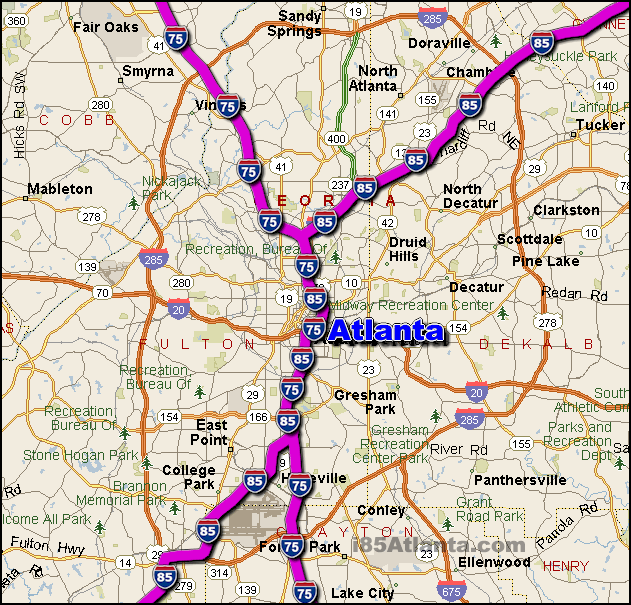
interstate 75 and 85 metro atlanta route map


Disclaimer and Privacy Policy, and Contact


Copyright  i85Atlanta.com


TOP